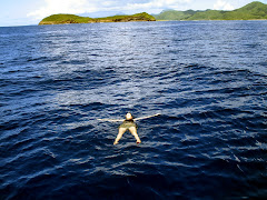
On Sunday I went with some friends to Palagi beach, translated into “the beach for white people”. The reason for this “exclusivity” is given to the fact that, to reach the beach, there is a 15 minutes walk between boulders hit by waves, tiny (wide wise) paths on high cliffs, walk on waist deep water (that also requires good timing capability to avoid to be tossed around by braking waves --- another note, forget about getting to or living Palagi beach during high tide)… mainly it is a walk the only palagi (and very few samoans) would do to spend few hours on the beach (before high tides comes and makes the passage very very difficult and somewhat very dangerous too).
The beauty of this beach is that with a 15 minutes walk, you enter in another dimension; you land in the deserted tropical island of Robinson Crusoe. Here you can be noisy if you are playing, relax, even wear a bikini! None will know!
Palagi beach is located on the westernmost point of Tutuila (our island), and, being it a US territory, also represent the westernmost point of the US.
“But Guam is farther west!” Replied Mike. Silence. I visualized a mental map of Polynesia… well, yes, in effect, Guam is definitely farther west... Why would the guidebook say so, then?
Then, the illumination…
In a fraction of a second, my mind left my body, still standing in Palagi beach, and flow high into the sky. I saw the island becoming smaller and smaller, almost immediately disappearing into the extends of the Pacific Ocean. Then, as I was getting farther and farther away, the Americans and the Asian continents appeared into the picture, and eventually I could see our blue planet suspended into the darkness of our galaxy. Rotating. One side sunbathing, the other in darkness. On the Earth, as seen from the place, there was not such a thing as today or tomorrow, or today and yesterday. There was only “NOW”.
But on men’s logical Earth, American Samoa is located in the realm of yesterday, meanwhile Guam is located in the ream of tomorrow.
If the Earth were a dog spinning in a circle trying to bite his tail, we would be the flies on the tail…
insomma, viviamo in culo al mondo!!!

I believe this is part of the magic of the island: it often puts you into surreal situations, new standpoints where you get a different perspective of the world or simply, of what you were used to.
And that was Palagi beach Sunday’s magic (it sounds like an ice-cream name…).


No comments:
Post a Comment